Saturday, November 14, 2020

Acorn Campground, New Melones Lake


Back at Acorn Campground with a spectacular views from site 53 of the hills and lake.  There weren't too many folks here over the weekend. 

Most folks were in sites 60-67. The only large group was a boy scout troop at sites 33-35. So, it was a very quiet camp for us.

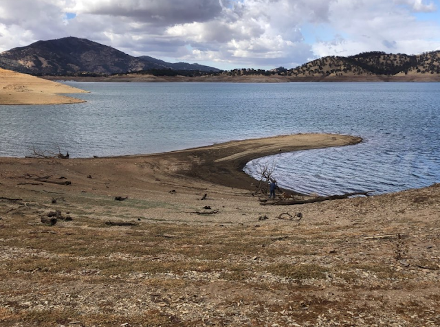
Our first hike (Saturday), we headed back to a place we hiked once before. We were shocked to see the water this low. We don't know if they emptied the lake in preparation for this winter's rains or if this is a result of not enough rain this past winter. 

We took the Black Bear Loop over to Cougar Point Trail. 

I'm standing close to the edge. I have to remember that at this area there is a picnic table, which makes for a great place to eat lunch.

What looks like large sticks are trees. This is looking across the cove from the point. 

While we climbed down to let Meeks have a drink of water, a couple of kayakers were enjoying their time exploring by water.

On the way back up to the trail, we stopped to look at this rock formation which looks like a tree had turned to petrified wood. 

Heading back to camp, we spotted our RV. The picnic table for the site is to the right. To get to the table it is a steep and short climb. They need to get the boy scouts to do a scout project of building steps into the short hillside from the parking pad to the level ground by the picnic table. We got back in time before a light rain started.

After a peaceful night of rest and a yummy breakfast of hash browns with eggs( I just had veggies with my browns), we headed off to do a longer hike than the day before. 

We started from the campground and took the Heron Point Trail down to just one of many points along the trail. This section of the trail that leads to this point isn't on the map, but there is a trail that extends from the main trail to this point. Again, we were shocked at how low the water had gotten. I'm somewhere down there looking for a good spot for Meeks to drink some water.

After exploring this point, we headed back to the main trail and hiked around the Heron Point to Redtail Trail. 

This oak tree looks like a large bonsai to us. From Redtail Trail, we took Ringneck Run over to the Lupine area. 

Along the Ringneck Run and very close to the Lupine Day Use area sits this huge truck tire. We wondered how it got there. Maybe at one time the water covered this area of grassy land and as the water receded the tire that was once floating here sank to this spot; or, a group of kids rolled the tire up to this spot from another location closer to the lake. It just looks so weird sitting in this location. We finished our hike by picking up the Black Bear Loop by the dump station to head back to the campground. 

Next morning (Monday), we awoke to a beautiful blue sky. Our last hike was a short one from Heron Point Trail to the Park's Entrance Station and back. The hike along the trail gave us an excellent view of the lake and bridge. We have driven across that bridge many time to get over to the Glory Hole Campgrounds, which is one of our favorite places to winter camp.


Tuesday, August 4, 2020

Clark Fork

I immediately thought of Clark Fork Campground, a first-come-first-serve campground, in the Sierras that would met our needs for our weekend adventure. It had been four years since our last time at this pretty camp. Sadly, two years ago a fire devastated a large area of this region of the Stanislaus NF. 


Thankfully, the campground was spared from fire. And thankfully, we were lucky to get a site on a Friday--a very nice and large site at that! 


Our nearest neighbor was through the trees.


And nobody behind us, only woods and a seasonal creek.


The previous camper's child had constructed a delightful greeting for us, a mini campfire or maybe this was a fairy home. 

After settling in and eating lunch, we headed off to the Arnot Creek trail. We had done this hike with our daughter four years ago. So we were eager to see what it looked like after the fire.


We hiked from the campground to the trailhead, about a mile. Along the way, we hiked by this huge logging truck. 


Sadly, the path looks like this for about a mile. 


We remember this hike being under a green canopy of pretty pines. Since it was hot and we were tired, we hike up to the sign post at Woods Gulch. There we explored an open meadow before turning back. 


On the way back to the campground, we cross the bridge that goes over the Clark Fork. 


We hiked about 5 miles that first day, just long enough to tire us out. We showered, ate, strolled the campground checking out neighbors, and retired early to bed that evening.

Second day's plan was to hike up to Boulder Lake, but that didn't happen. We did have a delightful hike!


We parked at the end of the road by a pretty meadow that sits below the Iceberg. 


We were surprised to see two horses munching away in the meadow. The white horse would follow the brown horse. At one point, the brown horse started to come over toward us, but then quickly stopped. There is a metal fence along the Clark Fork trail. It looks like the fence goes around the perimeter of the meadow. 


Not far from the trailhead, the trail has a short, steep climb. This ascent provided us with a rewarding view of the Iceberg and....


... a specular view of the canyon. All is lush and green. Thankfully the fire didn't come through the canyon. After the climb, the trail takes a short, gentle descent and then parallels the river, Clark Fork. 


Meeks drank from the icy cold river. That was her reward for making the ascent!


We stopped often to explore the beauty of the river.


And even found a couple of places with sandy beaches. 

After a couple of little stream crossings, we came to Boulder Creek, ~ 2 miles. We looked around for a junction post for Boulder Creek trail, but we didn't see one. So, we continued on the trail for about another half mile. The trail starts its climb out of the canyon towards Mary's Pass at this point. We realized that we hadn't seen the junction or a marker. So, we head back to Boulder Creek to find the junction, but we never did find the trail. That may be due to large downed trees obscuring the trail.


So, we abandon the idea of making it to Boulder Lake. It's not running away. We will keep it on our bucket list for future hikes in this region. 

 
On the way back to trailhead, we notice a cave up high in a large granite formation. 


On the same granite formation are some trees growing. Their root structure must not be very deep or large.


After our descent and close to trailhead, we take time to admire the beauty of the growth of this dead tree. We take note of the cracks and noticed the center, the origin.

Back at camp, we rest from another 5 mile hike.


Yes, we will be back to explore more trails, like Disaster Creek.

Friday, July 10, 2020

Jackson Meadows Lake


Our first outing of the year was to Jackson Meadows Lake, northwest of Tahoe. We stayed at East Meadows Campground, which wasn't crowded the day after the 4th. We were able to make reservations for two nights, July 5, 6. Since we didn't know how many folks would be out camping due to COVID-19, we decided to make reservations. We had heard some campgrounds are always full because folks aren't able to travel by plane to far destinations this year due to COVID. Normally, we are able to find a first-come-first-serve campsite without worrying about reservations.


There were only two other campers close to us. One left 8:30 AM Monday and the other had a medical emergency that they had to head home Monday night. So our area of the campground was very quiet.


We settled into site 39 which was nice, but too close to the campsites on either side of us. So, it was nice when those folks left. The ideal sites in this campground are sites 4, 30, 34, 42.


We only walked around the campground and looked at the lake on the first day since we were tired from our early start and the five hour drive. Sadly, the majority of the campsites do not have a view of the lake.


After a good night's sleep and a yummy breakfast of veggie hash browns with salsa, we headed up to the PCT.


We headed southbound on the PCT making a gradually climb.


The start of this portion of the trail is under a canopy of mossy evergreen trees, possibly Ponderosa pines. 


After about a mile climb the trail narrows and we passed this pile of rocks. Yes, it is very steep. Thank God those rocks didn't decide to slide down while we were passing this section.


Just when we were starting to doubt being able to have a view of the lake, we emerged from the dense forest. This was short-lived as the trail soon took us further up and into another portion of the forest.


This portion of the trail is part of a forest restoration.


Back in 1992, harvesting was done to encourage new growth and a healthy forest. 


We continued the ascent until we came to a barren area with a glorious view of English Meadows, the valley below. We were now about 3 miles into our hike. We debated on continuing another half mile or heading back.


We pushed on and glad we did for the views just got better, which made it well worth the climb. We passed lava formations from millions of years ago. See the little arch!


I needed to take a rest since I was feeling the effects of the altitude. We started around 6300 feet and most likely climb to about 7000. Plus, we needed to stop often for our dog. She's 15 years old.


Somehow we missed this spectacular view of the lake and Sierra Buttes on the way up. I guess we were too focused on the climb. So, it was a nice reward on the descent back to the campground.


We all took an afternoon snooze after our beautiful 6.9 mile hike.


Husband thought these rocks looked like penguins. I thought of turtles. We enjoyed our stay and hike, but next time we venture in this region we will explore the Lake Basin area.