Wednesday, November 6, 2019

New Melones

We stayed at Big Oak campground at New Melones Lake the weekend after Halloween.


Not that many campers; so, the campground was mostly quiet. Our site was very private with a view of the lake.


We did have to unhitch and pay at the boat ramp area this time since the Bureau of Reclamation had closed the pay boxes at the campground. 


The weather was perfect. Not too hot for a wonderful 5 mile hike around a portion of the lake via Carson Creek Trail, then Tower Climb to the top of the hill, and back down to the campground.


The evening was perfect too, not too cold. The cold morning made it difficult to get out from the warmth of the bed to take the dog out for her morning business. Staying under the covers relaxing and snoozing for another hour would have been wonderful, but we did get an extra hour of sleep in due to time change.

Tuesday, October 8, 2019

Frazer Flat

We headed back to Frazer Flat before the campground closes for the season. I think some of the lower elevation campgrounds could stay open until mid November, but that is my opinion.


We hiked from the campground to Strawberry by Forest Road 4N13. Roundtrip was 8 miles and the hike was a moderate to easy hike along the North Fork of Stanislaus River.


In Strawberry, we came across numerous extremely large "cabins". I fell in love with this interesting modern cabin. I could spend hours on the deck reading and watching nature.


There are a couple of forest roads that intersect with 4N13. We saw a couple of cyclist heading up this one, and we saw a bike path that some of the locals must have made connecting the two roads.


Back at camp, we enjoyed the beauty of the river while Meeks enjoyed a very long drink.
Next spring we will return to Frazer Flat to hike the beautiful 4N13.

Sunday, August 18, 2019

Spicer Reservoir

It's been twelve years since we last camped up around the Spicer area of the Stanislaus NF. Utica was our favorite place to car camp before a Sunset magazine article informed folks of peaceful Utica.


Now that we have a travel trailer, I wouldn't take my RV down to Utica. Plus, during the peak months of summer the lake is always crowded with campers, even midweek.


Our plan for the weekend was to head back to Pine Marten at Alpine Lake since it had been two years since our last visit. I wanted to hike Bee Gulch trail (part of the Tahoe-Yosemite Pack Trail system), but a huge event was happening that weekend in Bear Valley, which we didn't know until we got there. All the camping sites around Alpine lake were taken.


So we headed to our backup, Spicer. We nervously drove the 8 some miles down to Spicer campground hoping that there would be at least one site still vacant since Spicer is out of the way from Hwy 4 and the event. To our surprise half the campground was vacant. We were told if we had come last weekend we wouldn't have found a site. Since schools already started in the Central Valley and most of the schools in the Bay Area were starting Monday, we got lucky with lots of vacant sites to pick from.


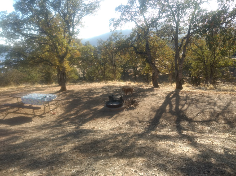
We picked site 6, a mainly private wooded site.  Our closest neighbors were in sites 4 and 7, which were quiet senior citizens with their huge RVs.


It had been at least 17 years since we camped at Spicer campground. We had forgotten the beauty of this area. The water was never this high in the numerous times we visited the lake while camping in this area. The views looking at the Carson-Iceberg Wilderness and the Dardanelles are truly stunning.


After settling in and having lunch, we headed up to Elephant Rock Lake for a hike to Rock Lake. This area too had changed.


Elephant Rock Lake seemed larger than we remembered it. This could be true since this year the Sierras had lots of snow. We remembered a much small lake with lots of waterlilies covering the entire lake.


We headed off to Rock Lake in the Carson-Iceberg Wilderness after taking a peek of Elephant Rock Lake. The trail we took was the one we took 12 years ago with our kids. This trail isn't on a couple of today's internet maps, but the trail is still well used and marked. A marker sit close to the wilderness sign.


About 13 years ago there was a forest fire here that burnt a large area of the forest close to the trail.


It was wonderful to see the new growth, all about 6-7ft in height. Beautifully shaped Christmas trees. We noted three different types of evergreen: spruce, pine, and fir. There are lots of dead trees that have fallen. Those decaying trees will bring nutrients to the new growth as well as to the alpine flowers: Indian Paintbrush and Woolly Sunflower.


We did a lot of climbing over downed trees that had fallen over the trail in the 2 miles that it took to reach Rock Lake. A great butt workout!


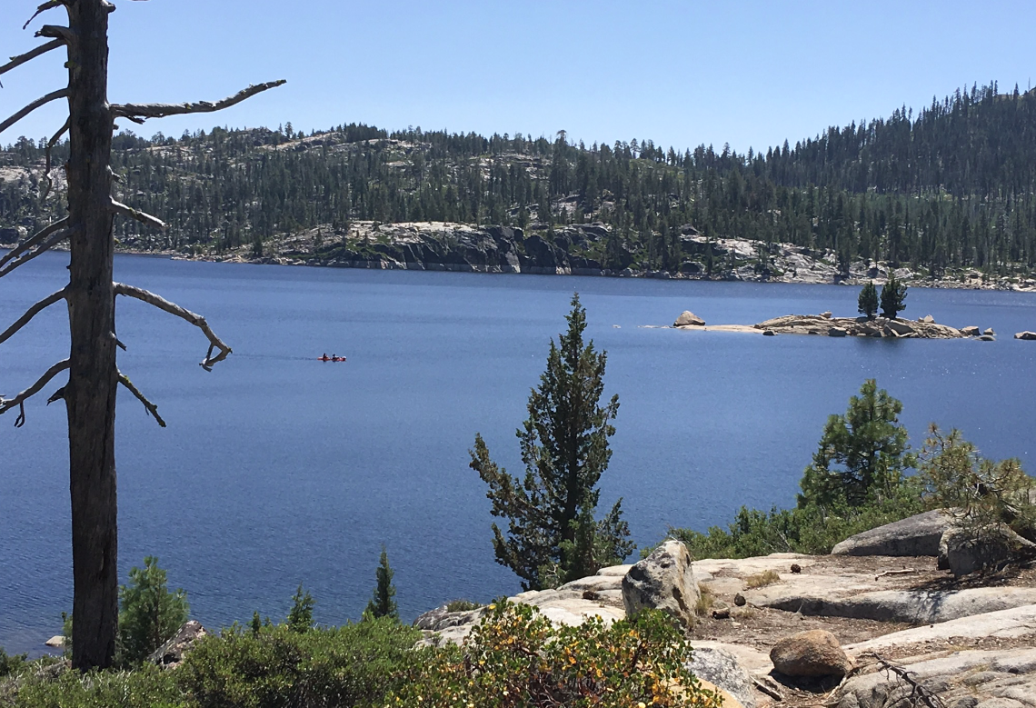
Rock Lake also looked a lot larger than what we remember. Again, this winter had a huge snow fall; so, we are most likely seeing the effects from the melting snow. This is only a small portion of the lake, western end. The trail traverses to the eastern end of the lake where the trail meets up with the Tahoe-Yosemite Pack Trail that passes by Alpine Lake. After a peaceful rest at the lake, we headed back to the car and then camp for a relaxing evening and yummy meal of Pad Thai.


Then next morning, we hiked and explored the road down to the dam. Along the way we came upon these large pulleys and then...


...this stone with the information on Martin McDonough, who was responsible for bringing a community together in seeing the importance of the power and purpose of the water in this region.


While hiking down to the shoreline, we noticed a couple of fire rings close to the shore.


We will not wait another seventeen years to venture back to Spicer Family Campground. Yes, it's now on our favorite places to RV camp! Next time, we will hike from Elephant Rock to Duck Lake. 

Monday, July 1, 2019

Relief Reservoir

Hiking to Relief Reservoir has been on my bucket list for way too long. My husband asked where are we heading for this weekend's hike and getaway weekend. I told him east and a high elevation with few crowds--hopefully. So we headed towards Kennedy's Meadows off just off Hwy 108, but everyone else had the same idea for camping in that area. It was too crowded for our liking.


Instead, we check the other campgrounds near Kennedy Meadows and then found a quiet spot in the Dardanelle campground, across from the burnt down Dardanelle Resort.


Two years ago a fire destroyed a huge area of the pristine forests on Hwy. 108. This campground was partially burnt.


The Stanislaus river runs just below our campsite. The steps leading down to the river were completely destroyed that it isn't safe to use them.  There is a sign stating that it isn't safe and the area below is restricted to use. Almost all the the pines that covered the peak across the river were burnt.


After settling in and eating an early lunch, we headed back to the trail head parking lot at Kennedy Meadows. From there we hiked past all the campers and folks enjoying the amenities of the resort to start our strenuous and beautiful climb to Relief Reservoir.


There were numerous groups of hikers heading up, but we hiked most of the time with nobody close by us.


We did pass a family of four with their goats hauling their camping paraphernalia. One goat just didn't want to climb the mountain. And here I thought all goats loved to climb, but not this one.


The river was flowing swiftly from all the heavy amounts of snow fall this past winter and spring.


The views were spectacular! This hike is up there in ranks to the Yosemite hike that I did with my son four years ago. The huge reward with this hike was that there were no crowds. Few folks were hiking this trail compared to the hundreds the make the climb to Vernal Falls.


The green, the granite, and the waterfalls were all stupendous!


And our little "goat" just kept on climbing.


We came across some pulley system that was left to retire after being used to build the dam.


After numerous hours of climbing, we came to a vista above the north end of the lake.


We found a perch among the granite to rest our weary bodies and nibble on some snacks while enjoying the beauty of the reservoir.


On the way back down, we had the trail mostly to ourselves. We enjoy the serenity of the canyon as we made our way back to Kennedy Meadows.


After two bridge crossings, the trail heads to the pretty meadow. Will we come back here again to hike this gorgeous area? You bet we will!!

Wednesday, May 1, 2019

Seasonal Creeks and Waterfalls

We headed back to Wakalu Hep Yoo Campground off of Hwy 4 this past weekend.


Nobody was around our location of the campground. Everyone wanted to be at the end or back where it was dark and wet.


We were at site 2, which is located across from the camp host site and near the exit and entrance. Not even the camp host had arrived for the first weekend of the season.


That's correct! Nobody was around us. It was like we had the entire campground to ourselves. Just the way we like it, peace and quiet.


When we camped here last fall, this creek wasn't flowing. This is close to the entrance to the campground. We could hear this creek and the river from our site, a very soothing sound.


Luckily for us, a very large group of off-road vehicles had finished their touring of the road we wished to hike. They were all parked at the day-use area, Sourgrass, when we headed up the road to explore what mother-nature had created.


We were surprised at the numerous seasonal creeks that we encountered. Last fall the road was dry and there was only one creek to cross.


This is what the creek looked like in the fall.


And this is what the creek looks like this spring. We couldn't even cross the creek to continue on the road.


So as we headed back, we enjoyed the waterfalls.


One creek had numerous falls. If we were younger and willing to climb up the hill, it would have been fun to explore those falls too.


After a relaxing evening and a peaceful sleep, we explored other areas of the campground and found this snow plant hiding under a young pine.


The path under the bridge lead to this swollen creek. We didn't feel like crossing what looks to be a slippery bridge.


So instead, we crossed the bridge and explored a portion of the trail across from the day-use area before heading back to camp for lunch and breaking camp. Next time we visit here we will explore the rest of that trail.