Showing posts with label buttes. Show all posts

Wednesday, July 19, 2017

Alpine Lake

The Sierra Mountains were calling us to come hike and camp. So, we packed up for an overnighter and headed away from the 100+ degree heat at home.  Yes, that's snow!


After setting up camp at Pine Marten and eating shrimp salad for lunch, we headed for a hike to Duck Lake.


Instead of finding ducks, we saw lots of geese that are spending their summer at 7,300 feet elevation trying to stay cool. The temperature for that day was 85 degrees.


Since the hike down to Duck Lake was only about a mile from the trailhead, we decided to hike around the lake to explore the other side of the lake. The trail was pretty and in numerous spots we lost the trail due to washouts from the spring melt. There are lots of fallen trees in the dense forest on the east side of the lake.


The views of the lake and granite mountain range are best seen on the west side of the lake. We didn't see any snow patches along our hike.


Back at camp, we enjoyed a relaxing and quiet Sunday afternoon with the cool, pine breeze blowing through our campsite.
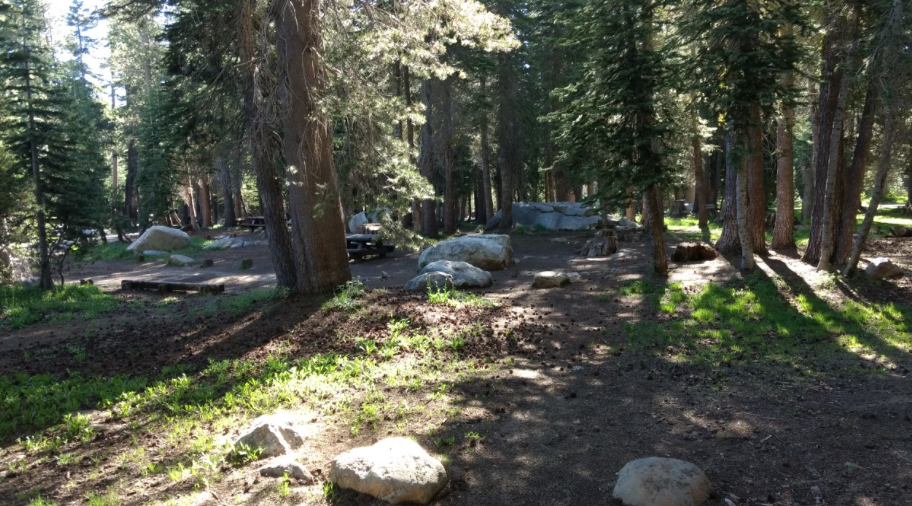

Most of the campers had left earlier in the day; so, four of the campsites by our site were empty.


All of the campsites located on the road to the right were empty too. There were some very nice sites for RVs on that section of the campground. One site in complete shade. Most of the campers were at the sites by the lake, which surprisingly was warmer there by the lake.


Through the trees, off on the right by the large log was a little pond that had formed from melted snow. Also, the trailhead to Inspiration Point was off on the left. Numerous cars were parked to the left of the photo, but by evening only one car was left.


After a good nights sleep and yummy breakfast, we hiked up to Inspiration Point. It was a steep climb to the lower level of the point.


We were rewarded with a wonderful view of Alpine Lake. The campground is off to the right of the photo. We could see folks kayaking and enjoying their day on the lake.


We scrambled higher for even more spectacular views.


We were delighted and surprised to see Utica, Union, Spicer Reservoirs. Basking in the view brought back wonderful memories of tent camping at Utica with our children over ten years ago. We could even spot the island which we canoed out to explore with the kids and Meeks.


And we had a view of the Dardanelles with the snowy mountains of the Emigrant Wilderness behind. Last August, we hike with daughter to Sword Lake just below the Dardanelles, http://tootlingaroundamt.blogspot.com/2016/08/.


The Dardanelles and Inspiration Point are like volcanic islands in a sea of granite. Glaciers eroded most of the volcanic rock and left moraines of granite. The Dardanelles are another example of an inverted volcanic river topography.


Back at camp, we relaxed before packing up and heading home to the heat of the Bay Area. We are looking forward to coming back here to explore more of this beautiful region of the Sierra Mountains.


Wednesday, April 26, 2017

Inverted Valley

After hiking up the buttes by Black Butte Lake, I started to research on other areas closer to home where ancient volcanoes created interesting and unique geological structures.

Tuolumne Table Mountain between Jamestown and New Melones Lake is an inverted valley miles long. One is able to hike up to the top for spectacular views of New Melones Lake and the Sierras.


Nine million years ago, a volcanic eruption sent lava flowing into a river bed where the lava hardened  as it cooled in the river. Slowly over time, the soft soils surrounding the igneous rock eroded leaving an inverted valley.


While following the trail, my husband and I missed the junction/bend in the trail that heads to the top. Instead, we followed the trail that passes by two caves and ends at this pile of boulders. We did climb up a bit thinking this was part of the trail, but we quickly realized that we had missed the junction.


We did see some climbers and other folks exploring this area. The 4.6 mile trail starts at the end of Shell Road on BLM land. Dogs are allowed on the trail. 


After a wonderful time exploring the Inverted Valley, we headed back to camp at Tuttletown Recreational Area. We were located in site 12 of the Acorn Campground. Most of the campers were situated up the hill, far away from our location. Nobody was at the site next to us; so, we had a quiet evening. 


In the morning while drinking tea and relaxing under the beauty of the oak tree, I listened to the birds. Wild Turkeys, Bobwhites, Quails, and Woodpeckers were busy making their presence to mother nature.

Later in the morning, we explored the trail from the campground down to the lake. From that trail, we followed numerous other trails to create a loop back to the campground. We were very surprised at the wonderful trail system throughout this recreational area that we are looking forward to returning again to explore more of the trails.


Saturday, December 31, 2016

Last Camping Trip 2016

With the kids home for Christmas, we headed back for an overnighter to Black Butte Lake so that the kids could experience the beauty of this region from the top of the butte.


The hike to the butte was well worth the effort. From the top of the butte, we had spectacular views of the Coastal Range and snow covered Mt Shasta in the far distance.


Even though the temperature was cold that day, the top of the butte was much warmer than down by the lake. After our hike back to an almost empty campground, we settled in the RV for the night to stay warm and relax. We ate a tasty meal of ham and bean soup with bacon buns and then played Blokus for hours.


Hopefully this is the start of a new holiday tradition for our family.