Tuesday, September 26, 2023

Fraser Flat


Fraser Flat Campground is one of our favorite campgrounds in the Stanislaus NF since there are numerous forest roads to hike and explore located close to the campground. 


We got lucky by arriving around 10 AM to snag site 7. We snagged this site last year. It is located away from the river and closer to the road 4N01, which means away from the crowds. We really don't use the picnic area of this wonderful site. Instead, it's fun sitting up by the RV watching other campers' children bicycle around the loop below the site. 

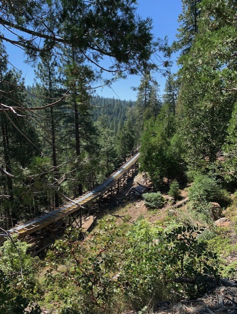
After settling in and having lunch, we hiked 4N61 from campground to 4N14 and back, about 5 miles. We noticed some bear scant heading up to the junction of 4N61 and 4N13, close to the flume. This year there was one person camped up the hill near the flume. 


On Sunday, we hiked the 4 miles along 4N13 that follows the flume/ditch on the north side of the Stanislaus River into Strawberry and another 1.5 miles to the Strawberry General Store. The General Store is just ok. Our return trip to camp was by way of Old Strawberry road and then the Strawberry Grade Trail down to Fraser Bridge. That trail is very pretty with a gentle incline since it was once a railroad bed. Total hike was 10.2 miles. The hike on 4N13 had four steep inclines.  Next year we'll just hike the Strawberry Grade to town and back to omit those grueling elevations.


Wednesday, August 30, 2023

Hope Valley Campground


We got lucky the weekend before Labor Day weekend by snagging a first-come-first-serve site at Hope Valley campground.  Five years ago, we tired to camp here but found the campground full.


This time we left earlier to arrive in time to claim a wonderful site away from the main campers.


Nobody was at the double site on one side of us, and the other side was forest. Each campsite was very well maintained!

We wondered if the picnic table was sitting low due to heavy snows sinking the table down into the ground. 


Across the street from the campground is Hope Valley. It's a gorgeous valley!! After lunch and a short nap, we headed across Blue Lakes Road to explore the area.


The west fork of the Carson River runs through the valley.


The short trail just takes one to the river, which was very low. After exploring this area, we headed to Faith Valley to do a short hike. 


Five years ago, we didn't know the name of this valley that we had dispersed camped. I thought is was all part of Hope Valley, but this year we learned that there are two separate valleys. 


I did remember a short hike that starts at the Faith Valley parking lot. This trail runs parallel to Blue Lakes Road with a slight incline and ends at the road. We did this hike to get acclimated to the 7,000 + ft before our more strenuous hike the next day, Sunday. 

Returning back to the car, we noticed some other hikers coming from the valley on another trail, which is difficult to see and has no trail marker.


Folks with horses use this trail, a known horse trail. After talking to the hikers, they told us it is about a 7 mile round trip hike that follows the river. We hiked a small portion of the trail through this huge meadow before heading back to camp for the evening. 


 Five years ago, we had hiked on the PCT heading south due to the heat and wanting to be under the canopy of pines. This year, we headed north on the PCT in the direction of the Nipple. 


Yes, that is the name of the mountain next to Blue Lakes. The PCT doesn't go to the top at 9342 ft, thank God! 


This hike started at the parking lot. We hiked about .45 miles before crossing Blue Lakes Rd and then heading up through the pines. 

After a mile or so climb on the PCT, the trees disperse...


and spectacular views to the south are our first reward.


Overall this section of the PCT isn't very steep. 


We came across numerous patches of a California native, Wooly Mule's Ears. 


And to our delight, we saw hummingbird moths feasting on the coyote mint. 


We found some rocks to sit at while eating lunch and taking in the view of Lower Blue Lakes. 


There were patches of snow with some pink snow. This is caused from algae that turns the snow pink and speeds up the melting of the snow.


I found this patch of pink penstemon to be prettier than the pink snow. 


Before packing up and leaving on Monday, we took the trail from the campground and followed it about 1.5 miles before turning back. It was getting hot. We did chat with someone on his bike exploring the trails. He had ridden from Faith Valley disperse campground over to Hope Valley campground without a map or knowing where the trails would go. I found this Topozone's map after returning home. Wish we had had it before heading out on the trail from the campground. 

Hope Valley and Faith Valley will be calling us back to explore the trails that we discovered on this trip and to enjoy the peaceful and beautiful campground again.




Friday, April 14, 2023

Easter, Water, And Irises!!!

 On Easter weekend we headed out to our favorite winter camping spot at New Melones Reservoir. Yes, it was the beginning of spring, but the heavy winter rains had prevent us from camping in winter this year.

We had been keeping a tab on the water level risings.


This is how much water was there end of October 2022. 


This is how much water was there in March 2022.


And this is how much was there April 2023.


 It's at 95% historical average, meaning just a little above half full. 


Last October, there was no water at the one boat ramp.


This April not only was there water, but a boat dock for this area was under construction.

We have never seen it this green here. All the flowers were in full bloom. A beautiful field of flowers right beside the campsite, so perfect!!


We could see the water from our site!! We had fun watching the swifts flying around and checking us out. They were very curious as to what we were doing at the picnic table.


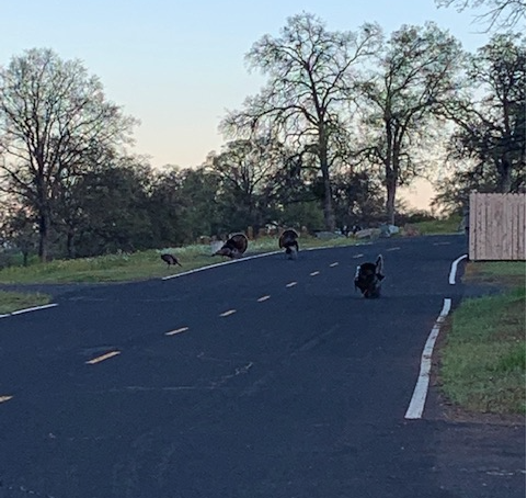
The wild turkeys had fun roaming the campground and we had a blast watching them.

One of our favorite trails, the Tower Trail was full of surprises too!


Someone must have planted these Irises as a memorial for a pet or loved one. 


With the heavy snowpack at higher elevations, we might not be able to get to some of our favorite summer campgrounds sites until September, if the NFS opens them at all this year.


Sunday, November 6, 2022

Where Did the Water Go!?

 New Melones Reservoir is drying up. 

Where did the water go? This section near Ironhorse campground has no water. 


This was how it looked in March. We had a feeling we would be seeing no water. 


We walked from the road all the way to the closed boat launch area.  


We did find some water, but this is so sad looking. No fish and no water birds were seen. We are concerned for the Ospreys that come here yearly. What will they eat?


Normally this is way under water. 


The cement bucket on top is for the buoy that now hangs down and is resting on the ground. Those close by hills should be under water too. 

Looking across at what should be all water. Where the green trees are is the location of the campground.  I can now say that I have walked on the bottom of this reservoir. 


Back at camp site, one can barely see some water through the trees. It's like "I spy" game. 


Some how the deer are hanging in there. These two are headed off to an acorn patch to munch on acorns before the sun sets.


A peek at the water level from the camp site across from our's. 


Sadly, California needs major storms this winter to fill up this reservoir and many others in the state. Hopefully the Sierras will get lots of snow so that the spring runoff will help fill the reservoirs.